|
Analemmatic Sundial Mathematics
/* analemmatic sundial computations for use in a program or speadsheet
with signs appropriate for southern hemisphere
longcor = longitude correction
e.g. longcor for Gauteng at 28 deg east = -8 minutes = -2 degrees,
Southern African Standard Time being for 30 degrees east time zone
lat = latitude,
e.g. Gauteng latitude = 26 deg south = -26 degrees
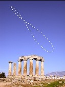
data needed for the analemma (dateline):
Sundec = declination of the Sun in degrees at date
ETmin = equation of time at date, in minutes
*/
date Sundec ETmin
Jan01 -23.067 -3.70
Jan15 -21.242 -9.27
Feb01 -17.333 -13.70
Feb15 -12.904 -14.13
Mar01 -7.817 -12.40
Mar15 -2.401 -9.03
Apr01 4.300 -4.00
Apr15 9.526 -0.13
May01 14.900 3.00
May15 18.706 3.68
Jun01 21.967 2.30
Jun15 23.277 -0.37
Jul01 23.150 -3.60
Jul15 21.625 -5.92
Aug01 18.167 -6.10
Aug15 13.942 -4.55
Sep01 8.500 0.00
Sep15 3.284 4.65
Oct01 -2.950 10.30
Oct15 -8.266 14.13
Nov01 -14.233 16.40
Nov15 -18.309 15.47
Dec01 -21.716 10.90
Dec15 -23.228 5.05
/* two constants are needed:
scale = scale size, 2.5 is good size in metres for walk on sundial
but 1.5 - 2.0 will be better for young people*/
scale=2.5;
/* dtr = degrees to radians conversion for libraries wanting trig functions
in radians; set to 1.0 if trig functions use degrees */
dtr=0.017453293;
/* time line, where Tdeg = standard time in degrees (1 degree = 4 minutes),
let Tdeg run from 06h00 to 18h00 at half hour intervals */
/* Xtime = M sin(T +/- longitude correction in degrees) */
Xtime=-scale*sin((Tdeg+longcor)*dtr);
/* Ytime = M sin(lat) cos(T +/- long. corr.) */
Ytime=-scale*sin(-lat*dtr)*cos((Tdeg+longcor)*dtr);
/* analemma Y axis = M tan(Sundec) cos(lat) */
Yan=-scale*tan(Sundec*dtr)*cos(lat*dtr);
/* analemma X axis = -M ETmin converted to degrees */
Xan=+scale*(ETmin/4.0*dtr);
This is a southern hemisphere example, for Gauteng Province in South Africa. Note the signs for Xtime, Ytime,
Xan, Yan.
/* sundlgtg.hst - Gauteng
                                                longitude correction for 28 deg east = -8 mins = -2 deg
                                                latitude = 26 deg south
                                                X = M sin(T +/- Longitude correction in degrees)
                                                Y = M sin(lat) cos(T +/- long. corr.)
                                                where T = SAST in degrees */
                                                Xtime=-2.5*sin((Tdeg-2)*0.017453293);
                                                Ytime=-2.5*sin(-26*0.017453293)*cos((Tdeg-2)*0.017453293);
                                                /* analemma Y axis = M tan(dec) cos(lat) */
                                                Yan=-2.5*tan(Dec*0.017453293)*cos(-26*0.017453293);
                                                /* analemma X axis = -M ETmin -> degrees */
                                                Xan=+2.5*(ETmin/4.0*0.017453293);
This is a northern hemisphere example, for Brocton in England. Note the signs for Xtime, Ytime, Xan, Yan.
/* sundlBRO.hst - for Brocton, England
                                                   longitude correction at 2d 02' 20" west = 8.156 mins = 2.039 deg
                                                   latitude = 52d 47' 40" north  = 52.778 deg
                                                   X = M sin(T +/- Longitude correction in degrees)
                                                   Y = M sin(lat) cos(T +/- long. corr.)
                                                   where T = Time Zone standard time in degrees */
                                                Xtime=+2.5*sin((Tdeg-2.039)*0.017453293);
                                                Ytime=+2.5*sin(+52.778*0.017453293)*cos((Tdeg-2.039)*0.017453293);
                                                /* analemma Y axis = M tan(dec) cos(lat) */
                                                Yan=+2.5*tan(Dec*0.017453293)*cos(+52.778*0.017453293);
                                                /* analemma X axis = -M ETmin -> degrees */
                                                Xan=-2.5*(ETmin/4.0*0.017453293);
|